#Resource
---
title: Why has it been so rainy?
source: https://www.bbc.com/weather/articles/cx2lz3k65w5o
author:
- "[[Met Office]]"
published: 2026-02-02
created: 2026-02-03
description: For many of us, the past few weeks have felt relentlessly wet. Repeated bands of rain have swept in from the Atlantic, leading to increasingly saturated ground, travel disruption, and a general sense that winter has been stuck on repeat.
tags:
- clippings
- weather
---
# UK weather Areas of UK hit by record January rainfall

A photo of flooding in Axminster, Devon
**Official statistics for January have been released by the Met Office and confirm what many will already suspect - it has been very wet for many areas.**
Northern Ireland, south-west and southern England, and the east of Scotland all had one of their wettest Januarys on record.
With 70% more rain than average Northern Ireland experienced the wettest January for 149 years. Culdrose in Cornwall recorded two and a quarter times its average, while Aboyne in Aberdeenshire had nearly four times its January average of 68.9mm.
The month also bought us an average amount of sunshine and a below average overall temperature, something that's increasingly rare as our world warms due to climate change.
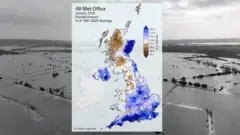
An image of the UK showing rainfall totals for January 2026 with blue for above average rainfall and brown for below average
Conversely, rainfall across north-west England and west Scotland was below average. You can see in the map above the areas coloured brown had less rain than normally expected in January.
That includes north-west England and western Scotland.
Altnaharra, in Highland, has seen 66mm of rain, which is less than half its January average. Aviemore has also had below the average as it has been very sheltered from the prevailing south-east winds by the Cairngorm mountains.
The reason it has been so wet for many is because of a blocking area of high pressure over Scandinavia.
As rain-bearing areas of low pressure have come in off the Atlantic, they've been prevented from moving through.
This has often resulted in a pattern of south-westerly winds in the south of the UK, and south-easterly winds in east Scotland. Areas exposed to those prevailing winds have had the wettest weather.
- [UK Flood Warnings](https://www.bbc.com/weather/warnings/floods)
The Met Office has issued a yellow rain [warning](https://www.bbc.com/weather/warnings/weather) for south-west England, valid between 18:00 Monday and 21:00 Tuesday with 10-20mm falling widely and up to 50mm over Dartmoor. The ground remains saturated and more than sixty flood warnings are in force even before this next batch of wet weather arrives, so further flooding is expected.
There are also yellow warnings for snow in north-east Scotland for Tuesday and Wednesday with 10-20cm forecast above 200m elevation and several centimetres at lower elevations, bringing the threat of some localised disruption.
Beyond the next few days of weather, the same blocking area of high pressure remains over Scandinavia for another two weeks. So it is likely that weather patterns will stay stuck in a rut with nothing changing substantially until mid-February.
That means the threat of more heavy rain with localised flooding in southern England and eastern Scotland where hill snow is also likely at times. We'll probably see more of a change in our weather patterns during the second half of February.
The great irony about all this rain is that technically a hosepipe ban remains in force for parts of southern England - that means you shouldn't go out watering your grass or plants, not that they'll be needing any extra water right now.
## More on this story
- [Storm names 2025-26: How do storms like Chandra get their names?](https://www.bbc.com/weather/articles/c3vz5pxdv75o)

Huge waves crash on to the beach in Falmouth, Cornwall, during Storm Ingrid, with masses of very high foamy water approaching the land to the left and a headland behind
- [Monthly Outlook](https://www.bbc.com/weather/articles/c1ee0klzvneo)

A train passes behind a body of water and in front of a rainbow
- [Tearful Carol Kirkwood announces she is to leave BBC](https://www.bbc.com/news/articles/cedwp8w1j24o)

Carol Kirkwood on BBC Breakfast, looking emotional
**Author:** Met Office
For many of us, the past few weeks have felt relentlessly wet. Repeated bands of rain have swept in from the Atlantic, leading to increasingly saturated ground, travel disruption, and a general sense that winter has been stuck on repeat.
January was particularly wet in southwest England, eastern Scotland and eastern Northern Ireland.
At the same time, hill snow has been a frequent issue in Scotland. The very wet and stormy conditions have also been impacting western France and Iberia at times too.
But what has actually been driving this unsettled spell? As is often the case, the answer lies high above us – in the fast-moving river of air known as the jet stream.
## What is the jet stream doing?
The [jet stream](https://www.metoffice.gov.uk/weather/learn-about/weather/types-of-weather/wind/what-is-the-jet-stream) is the main architect of our current weather pattern. This powerful ribbon of air, flowing several miles above the Earth’s surface, has often been strong and positioned further south than we typically expect at this time of year. When the jet stream shifts south across the Atlantic, it tends to funnel low-pressure systems directly towards the UK, increasing the frequency and intensity of rain-bearing weather fronts. Some intense wind storms have also occurred, such as Storm Goretti.
This winter, cold plunges across North America have helped to strengthen the jet stream. As that cold, dense air moves southwards, it enhances the temperature contrast between warm and cold regions – one of the key factors that energises the jet. A stronger jet stream acts a bit like a conveyor belt, rapidly developing and then propelling areas of low pressure towards north-west Europe.
At the same time, high pressure has also established over parts of northern Europe. This has created a ‘blocked’ pattern, preventing any significant shift in the position of the jet stream and limiting our chances of more settled, drier weather developing. This blocking high has also prevented the weather fronts pushing through and clearing the UK. Instead they have been stalling over the UK, leading to persistent slow moving bands of rain.
## Blocked pattern becomes stuck
The current setup has been remarkably persistent. High pressure has been anchored over Scandinavia, while repeated low-pressure systems continue to approach from the southwest. This combination has allowed wetter weather to push into western and southwestern parts of the UK in particular.
**READ MORE:** [Northern Ireland sees wettest January in 149 years as 2026 gets off to a wet and windy start](https://www.metoffice.gov.uk/about-us/news-and-media/media-centre/weather-and-climate-news/2026/northern-ireland-records-wettest-january-in-149-years-as-2026-gets-off-to-a-wet-and-windy-start)
When the atmosphere becomes stuck in this sort of regime, it can take time for the large-scale pattern to reset. The jet stream tends to follow the path of least resistance, and recently that path has been directly over the UK.
While short breaks in the rain have occurred, they haven’t lasted long. The underlying pressure pattern continues to favour new systems arriving before the ground has had time to dry out, giving the impression of almost continual wet weather.
## Will the rain ease in the coming days?
In the short term, the theme of unsettled weather is set to continue. With high pressure still lingering near Scandinavia, more rain is likely, especially for southwestern regions at times this week, as well as eastern Scotland (where further upland snow is also likely). This means some areas could see further issues associated with saturated ground and swollen rivers.
However, as we move into the following week, there are tentative signs of a subtle shift. High pressure looks more likely to build towards Greenland rather than Scandinavia. This small but important change could help northern parts of the UK turn a little drier for a time.
Forecast rainfall anomaly charts support this idea, suggesting that northern areas may experience slightly below-average rainfall during the second week of February. In contrast, southern parts of the UK are more likely to remain near, or slightly above, average for rainfall.
## Is there a longer-term change on the horizon?
Further ahead, as we head deeper into February, projections point towards the jet stream nudging northwards again. This would bring a return to the slightly south-shifted, mobile Atlantic pattern we’ve been experiencing through much of January.
This means we’re likely to see a renewal of the familiar cycle of low-pressure systems moving in from the west, bringing further spells of wind and rain. Even if there are brief quieter periods, current signals suggest they may be short-lived.